![](/images/other/stat-length.png)
![Tour Wandern La Hague - 50 Nez de Jobourg baie d'Ecalgrain 11km - Photo](https://media.geolcdn.com/t/1900/400/ea63df45-169f-41d1-8e4a-a0664d4d8e9b.jpg&format=pjpeg&maxdim=2)
50 Nez de Jobourg baie d'Ecalgrain 11km
SyMA
Benutzer
![Länge](/images/other/stat-length.png)
Länge
10,9 km
![Maximale Höhe](https://static1.geolcdn.com/siteimages/upload/files/1508320355ic_sort_altitude_max_24dp.png)
Maximale Höhe
128 m
![Positive Höhendifferenz](https://static1.geolcdn.com/siteimages/upload/files/1508320355ic_sort_den_pos_24dp.png)
Positive Höhendifferenz
326 m
![Km-Effort](/images/other/stat-length.png)
Km-Effort
15,2 km
![Min. Höhe](https://static1.geolcdn.com/siteimages/upload/files/1508320355ic_sort_altitude_min_24dp.png)
Min. Höhe
5 m
![Negative Höhendifferenz](https://static1.geolcdn.com/siteimages/upload/files/1508320355ic_sort_den_neg_24dp.png)
Negative Höhendifferenz
323 m
![Boucle](https://static1.geolcdn.com/siteimages/upload/files/16400158638029165_repeat_loop_refresh_sync_direction_icon.png)
Boucle
Ja
Erstellungsdatum :
2020-07-17 07:57:14.465
Letzte Änderung :
2020-07-17 17:27:01.323
![Wandern](https://static1.geolcdn.com/sitytour/trail-icons/101.png)
4h01
Schwierigkeit : Einfach
![Scannen Sie diesen QR-Code, um die Tour in der SityTrail-Anwendung zu öffnen](https://capi.geolives.com/qq0zvz2zws4bq2lad0pu/sitytour/trails/2479115/qr.png?size=200)
Kostenlosegpshiking-Anwendung
Über SityTrail
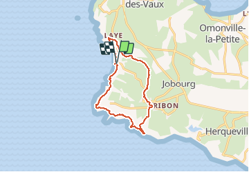
Tour Wandern von 10,9 km verfügbar auf Normandie, Manche, La Hague. Diese Tour wird von SyMA vorgeschlagen.
Beschreibung
Depart de parking de Baie D'Ecalgrain
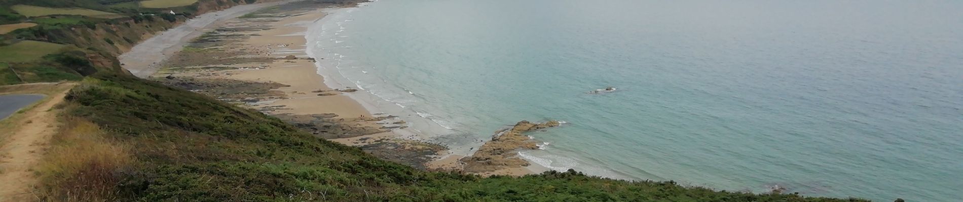
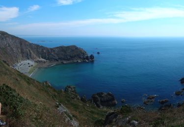
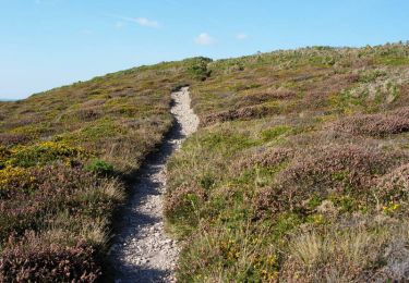
Belle rando en bord de Manche avec belles vues et retour par les terres
Point pique nique au hameau Dannery
Ort
Land:
France
Region :
Normandie
Abteilung/Provinz :
Manche
Kommune :
La Hague
Standort:
Auderville
Gehen Sie:(Dec)
Gehen Sie:(UTM)
576822 ; 5504750 (30U) N.
Kommentare
Touren in der Umgebung
![Tour Wandern La Hague - NEZ JOBOURG - Photo](https://media.geolcdn.com/t/375/260/c98676c9-55e7-4381-9b91-05c742077aaf.jpg&format=jpg&maxdim=2)
![Wandern Wandern](https://static1.geolcdn.com/sitytour/trail-icons/101.png)
NEZ JOBOURG
Wandern
Schwierig
(2)
La Hague,
Normandie,
Manche,
France
![](/images/other/stat-length.png)
21 km | 27 km-effort
5h 48min
![](https://static1.geolcdn.com/siteimages/upload/files/16400158638029165_repeat_loop_refresh_sync_direction_icon.png)
Ja
![Tour Mountainbike La Hague - Le Tour des Echoués - Jobourg - Photo](https://media.geolcdn.com/t/375/260/ext.jpg?maxdim=2&url=https%3A%2F%2Fservices.sitytrail.com%2FGeolivesWS%2FDownloadMedia.ashx%3FTrailID%3D173186%26Media%3D14770_5.jpg)
![Mountainbike Mountainbike](https://static1.geolcdn.com/sitytour/trail-icons/202.png)
Le Tour des Echoués - Jobourg
Mountainbike
Medium
(1)
La Hague,
Normandie,
Manche,
France
![](/images/other/stat-length.png)
26 km | 32 km-effort
2h 0min
![](https://static1.geolcdn.com/siteimages/upload/files/16400158638029165_repeat_loop_refresh_sync_direction_icon.png)
Ja
![Tour Wandern La Hague - Ecalgrain et sa baie. - Photo](https://media.geolcdn.com/t/375/260/ext.jpg?maxdim=2&url=https%3A%2F%2Fservices.sitytrail.com%2FGeolivesWS%2FDownloadMedia.ashx%3FTrailID%3D102758%26Media%3D3900_6.jpg)
![Wandern Wandern](https://static1.geolcdn.com/sitytour/trail-icons/101.png)
Ecalgrain et sa baie.
Wandern
Schwierig
(4)
La Hague,
Normandie,
Manche,
France
![](/images/other/stat-length.png)
13,4 km | 18,3 km-effort
3h 15min
![](https://static1.geolcdn.com/siteimages/upload/files/16400158638029165_repeat_loop_refresh_sync_direction_icon.png)
Ja
![Tour Zu Fuß La Hague - SityTrail - 4202124 - cotentin-j3 - Photo](https://media.geolcdn.com/t/375/260/0edaec19-e94e-4149-8092-0ff358c3dd07.jpg&format=jpg&maxdim=2)
![Zu Fuß Zu Fuß](https://static1.geolcdn.com/sitytour/trail-icons/100.png)
SityTrail - 4202124 - cotentin-j3
Zu Fuß
Schwierig
La Hague,
Normandie,
Manche,
France
![](/images/other/stat-length.png)
23 km | 33 km-effort
7h 30min
![](https://static1.geolcdn.com/siteimages/upload/files/16400158638029165_repeat_loop_refresh_sync_direction_icon.png)
Nein
![Tour Wandern La Hague - Séjour Cotentin Etape 3 Le nez de Jobourg et Biville a corriger - Photo](https://media.geolcdn.com/t/375/260/769074c5-2128-40cd-af27-847ab7c0e7c4.jpg&format=jpg&maxdim=2)
![Wandern Wandern](https://static1.geolcdn.com/sitytour/trail-icons/101.png)
Séjour Cotentin Etape 3 Le nez de Jobourg et Biville a corriger
Wandern
Sehr schwierig
La Hague,
Normandie,
Manche,
France
![](/images/other/stat-length.png)
23 km | 33 km-effort
7h 31min
![](https://static1.geolcdn.com/siteimages/upload/files/16400158638029165_repeat_loop_refresh_sync_direction_icon.png)
Nein
![Tour Zu Fuß La Hague - Séjour Cotentin Etape 2 Boucle Jobourg La Hague - Port Racine - Omonville la petite - Photo](https://media.geolcdn.com/t/375/260/c0e0de9e-3bd4-4319-af5c-c6b5aff35ffd.jpg&format=jpg&maxdim=2)
![Zu Fuß Zu Fuß](https://static1.geolcdn.com/sitytour/trail-icons/100.png)
Séjour Cotentin Etape 2 Boucle Jobourg La Hague - Port Racine - Omonville la ...
Zu Fuß
Schwierig
La Hague,
Normandie,
Manche,
France
![](/images/other/stat-length.png)
28 km | 34 km-effort
7h 44min
![](https://static1.geolcdn.com/siteimages/upload/files/16400158638029165_repeat_loop_refresh_sync_direction_icon.png)
Ja
![Tour Wandern La Hague - goury / vauville - Photo](https://media.geolcdn.com/t/375/260/ext.jpg?maxdim=2&url=https%3A%2F%2Fstatic1.geolcdn.com%2Fsiteimages%2Fupload%2Ffiles%2F1553511878bg_sport_marche.png)
![Wandern Wandern](https://static1.geolcdn.com/sitytour/trail-icons/101.png)
goury / vauville
Wandern
Schwierig
(1)
La Hague,
Normandie,
Manche,
France
![](/images/other/stat-length.png)
16,5 km | 24 km-effort
5h 17min
![](https://static1.geolcdn.com/siteimages/upload/files/16400158638029165_repeat_loop_refresh_sync_direction_icon.png)
Nein
![Tour Wandern La Hague - Magiquement votre - Photo](https://media.geolcdn.com/t/375/260/c49fffc8-7c79-42cf-a4d6-b3c2cf7eec90.jpg&format=jpg&maxdim=2)
![Wandern Wandern](https://static1.geolcdn.com/sitytour/trail-icons/101.png)
Magiquement votre
Wandern
Medium
La Hague,
Normandie,
Manche,
France
![](/images/other/stat-length.png)
25 km | 33 km-effort
6h 12min
![](https://static1.geolcdn.com/siteimages/upload/files/16400158638029165_repeat_loop_refresh_sync_direction_icon.png)
Ja
![Tour Wandern La Hague - Boucle St-Germain-des-Vaux - Auderville - La Roche - Goury - Photo](https://media.geolcdn.com/t/375/260/e5808f0a-2966-4fdc-bdca-55912ac6256a.jpg&format=jpg&maxdim=2)
![Wandern Wandern](https://static1.geolcdn.com/sitytour/trail-icons/101.png)
Boucle St-Germain-des-Vaux - Auderville - La Roche - Goury
Wandern
Einfach
La Hague,
Normandie,
Manche,
France
![](/images/other/stat-length.png)
12,4 km | 14,7 km-effort
5h 22min
![](https://static1.geolcdn.com/siteimages/upload/files/16400158638029165_repeat_loop_refresh_sync_direction_icon.png)
Ja